Spotlight Tasking
Overview
When tasking in Canopy, you can select SPOTLIGHT as your Imaging Mode, available through both the API and UI, to request and configure a Spotlight Task. When your task is scheduled, it triggers a Spotlight Collect, which provides high‑resolution imagery over your area of interest. This data is then processed into one or more deliverable assets.
By choosing Spotlight, you will task our default 5 × 5 km footprint.
If your organization has additional options enabled, you may also be able to request a Natural footprint scene size.
These options allow you to balance coverage vs. resolution depending on your needs.
Natural Footprint is not enabled by default. For more information about this product and how to enable it for your organization, see Natural Footprint.
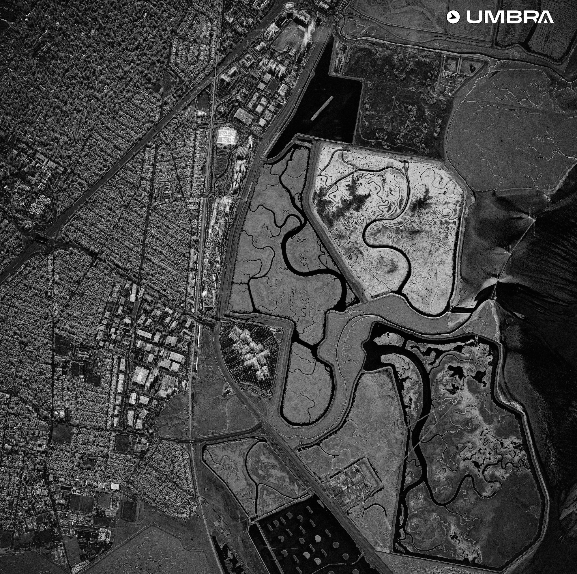
Default 5 x 5 km Spotlight Collect - Menlo Park, CA
Suggested Tasking Parameters
Umbra suggests the following minimum and maximum grazing angles for each combination of scene size, resolution, and looks when submitting Spotlight Task and Feasibility requests. These values allow for sufficient radar energy on the target area to return high quality images for most customer use cases.
For information on when to choose a particular resolution and multi-look combination, please see Multi-looking.
| sceneSize | rangeResolutionMinMeters | multilookFactor | grazingAngleMinDegrees | grazingAngleMaxDegrees |
|---|---|---|---|---|
| 5x5_KM | 1 | 2 | 37 | 80 |
| 5x5_KM | 1 | 1 | 42 | 80 |
| 5x5_KM | 1 | 2 | 37 | 80 |
| 5x5_KM | 1 | 3 | 33 | 80 |
| 5x5_KM | 1 | 4 | 32 | 80 |
| 5x5_KM | 1 | 5 | 32 | 80 |
| 5x5_KM | 1 | 8 | 32 | 80 |
| 5x5_KM | 1 | 10 | 32 | 80 |
| 5x5_KM | 0.5 | 1 | 55 | 75 |
| 5x5_KM | 0.5 | 2 | 47 | 75 |
| 5x5_KM | 0.5 | 3 | 43 | 75 |
| 5x5_KM | 0.5 | 4 | 40 | 75 |
| 5x5_KM | 0.5 | 5 | 40 | 75 |
| 5x5_KM | 0.5 | 8 | 40 | 75 |
| 5x5_KM | 0.35 | 1 | 63 | 69 |
| 5x5_KM | 0.35 | 2 | 55 | 69 |
| 5x5_KM | 0.35 | 3 | 49 | 69 |
| 5x5_KM | 0.35 | 4 | 45 | 69 |
| 5x5_KM | 0.35 | 5 | 45 | 69 |
| 5x5_KM | 0.25 | 1 | 53 | 59 |
| 5x5_KM | 0.25 | 2 | 48 | 59 |
| 5x5_KM | 0.25 | 3 | 45 | 59 |
Available Product Types
During Task creation, you can specify one or more product types to define the deliverables you want. The following product types are supported (availability depends on your organization’s configuration):
GEC — Geocoded Ellipsoid Corrected. Included with all tasks
SICD — Standard Imagery Complex Data (NITF).
SIDD — Sensor Independent Derived Data (NITF).
CPHD — Compensated Phase History Data (raw radar).
GeoTIFF — Cloud‑optimized GeoTIFF imagery.
CSI SIDD — Color Single Image Sensor Independent Detected Data (only for 5x5 scene size)
CSI TIFF — Color Single Image TIFF (only for 5x5 scene size)
DI GIF — SAR Movie (only at 1m resolution with 5+ looks at 5x5 scene size)
For more details on each format, see Delivered Product Types.
Related Guides
- Create a Spotlight task with the API or UI
- Head to the Umbra Product Guide for technical specifications.
Updated 5 months ago